Restaurant nearby Taverna ADIKE
Albania
Restaurant nearby Taverna ADIKE
Taverna ADIKE
Patos, Albania
contacts phone
:
+355
Latitude:
40.6881197
, Longitude:
19.607144
larger map & directions
read more
nearest Restaurant
4 m
TAVERNA ANTIKA
Patos
Restaurant
read more
751 m
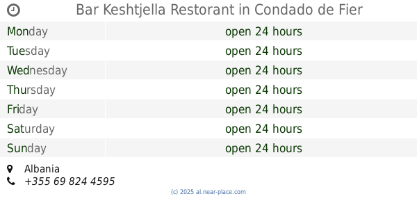
Bar Keshtjella Restorant
Albania
Restaurant
read more
1.91 km
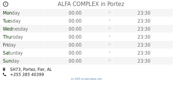
ALFA COMPLEX
SH73, Portez
Restaurant
read more
2.074 km
Fredi
Rruga Rripallareve, Patos
Restaurant
read more
2.37 km
Kompleksi Perla e Gjelbër
Rruga Fier-Berat Km 8, SH73, Verbas
Restaurant
read more
2.372 km
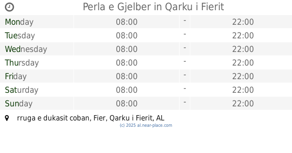
Perla e Gjelber
rruga e dukasit coban
Restaurant
read more
2.708 km
bar restorant raketa
Albania
Restaurant
read more
3.486 km
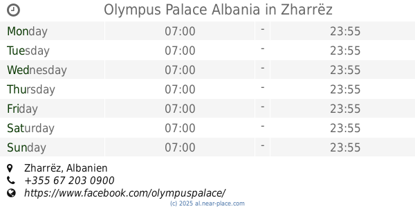
Olympus Palace Albania
Zharrëz
Restaurant
read more
4.086 km
Akropoli Restaurant
Qark Fier
Restaurant
read more
4.181 km
Restorant Piramida
Obwód Fier
Restaurant
read more
4.181 km
Restorant Piramida
Qark Fier
Restaurant
read more
4.181 km
Restorant Piramida
Fier
Restaurant
read more
4.22 km
Bar Restorant Natyra
Fier
Restaurant
read more
4.502 km
Bar Restorant Plepi
Lalar
Restaurant
read more
4.686 km
Bar - Restorant Panorama
Albania
Restaurant
read more
5.579 km
QILARI I VJETER
jani bakalli, 9303
Restaurant
read more
5.696 km
Piceria Nardi, Fier
40.719853, 19.554087, Rr. Ramiz Aranitasi, Fier
Restaurant
read more
5.753 km
Fish Market
Rruga Vasil Pecuke, Fier
Restaurant
read more
5.844 km
Pizza Italia Fier
Rruga Jakov Xoxa Fier 9301 AL, Rr. Jakov Xoxa, Fier
Restaurant
read more
5.919 km
Bar Restaurant Argjendari
Rruga Brigada IX Sulmuese, Fier
Restaurant
read more
5.938 km
Creperie
Rruga Pinellopi Piro, Fier
Restaurant
read more
5.995 km
Picer Piceri Portokallet Fier
Fier
Restaurant
read more
6.147 km
Toska Fish Restorant
Rruga Llambi Bego Lagja Kastriot, 9301, Fier
Restaurant
read more
6.273 km
Restorant Niku
9301, Rruga Brigada IX Sulmuese, Fier
Restaurant
read more
6.277 km
Loft Bar & Restaurant @Niku
Fier
Restaurant
read more
📑
all categories
Accounting
Administrative area level 1
Administrative area level 2
Airport
Amusement park
Aquarium
Art gallery
Atm
Bakery
Bank
Bar
Beauty salon
Bicycle store
Book store
Bus station
Cafe
Campground
Car dealer
Car rental
Car repair
Car wash
Casino
Cemetery
Church
City hall
Clothing store
Colloquial area
Convenience store
Country
Courthouse
Dentist
Department store
Doctor
Electrician
Electronics store
Embassy
Finance
Fire station
Florist
Food
Funeral home
Furniture store
Gas station
General contractor
Grocery or supermarket
Gym
Hair care
Hardware store
Health
Home goods store
Hospital
Insurance agency
Jewelry store
Laundry
Lawyer
Library
Liquor store
Local government office
Locality
Locksmith
Lodging
Meal delivery
Meal takeaway
Mosque
Movie rental
Movie theater
Moving company
Museum
Natural feature
Neighborhood
Night club
Painter
Park
Parking
Pet store
Pharmacy
Physiotherapist
Place of worship
Plumber
Point of interest
Police
Post office
Premise
Real estate agency
Restaurant
Route
Rv park, camping
School
Shoe store
Shopping mall
Spa
Stadium
Storage
Store
Supermarket
Taxi stand
Train station
Transit station
Travel agency
University
Veterinary care
Zoo
administrative area level 3
administrative area level 5
sublocality level 1
↑