Restaurant nearby go for run
Albania
Restaurant nearby go for run
go for run
Condado de Fier, Albania
contacts phone
:
+33 6 75 36 93 21
Latitude:
40.7346859
, Longitude:
19.5732683
larger map & directions
read more
nearest Restaurant
37 m
Taverna
Fier
Restaurant
read more
445 m
Pizza Corner
Fier
Restaurant
read more
525 m
Pizzeria BELLA NAPOLI FIER
Rr. Skenderbeu, Fier
Restaurant
read more
567 m
Bar Restaurant Peshku
Fier
Restaurant
read more
667 m
Sweet Waffles
Rr. Skenderbeu, 3, Fier
Restaurant
read more
929 m
Kompleksi ALBES
Fier
Restaurant
read more
1.039 km
Taverna Fatosi
Fier
Restaurant
read more
1.114 km
Creperie
Rruga Pinellopi Piro, Fier
Restaurant
read more
1.158 km
Pizza Italia Fier
Rruga Jakov Xoxa Fier 9301 AL, Rr. Jakov Xoxa, Fier
Restaurant
read more
1.171 km
Metropolitana
Fier
Restaurant
read more
1.409 km
Picer Piceri Portokallet Fier
Fier
Restaurant
read more
1.459 km
Piaca
Rruga Kastriot Muço, Fier
Restaurant
read more
1.504 km
QILARI I VJETER
jani bakalli, 9303
Restaurant
read more
1.527 km
Bar Restorant Fenix
Lagja 1 Maji, Rruga Jani Bakalli, Fier
Restaurant
read more
1.737 km
Piceri Ciao
Rr. Xoxi Andoni, Fier
Restaurant
read more
1.757 km
Bar Restaurant Argjendari
Rruga Brigada IX Sulmuese, Fier
Restaurant
read more
1.801 km
Bar&Restorant Dafinat
Albania
Restaurant
read more
1.925 km
Loft Bar & Restaurant @Niku
Fier
Restaurant
read more
1.925 km
Restorant Niku
9301, Rruga Brigada IX Sulmuese, Fier
Restaurant
read more
2.006 km
Fish Market
Rruga Vasil Pecuke, Fier
Restaurant
read more
2.007 km
Fiesherman (Peshkatari)
Rruga Miço Plaka, Fier
Restaurant
read more
2.063 km
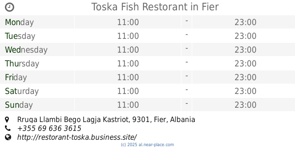
Toska Fish Restorant
Rruga Llambi Bego Lagja Kastriot, 9301, Fier
Restaurant
read more
2.309 km
Piceria Nardi, Fier
40.719853, 19.554087, Rr. Ramiz Aranitasi, Fier
Restaurant
read more
2.427 km
Garden Grill
Fier
Restaurant
read more
2.619 km
Bar Ulliri
Rruga Aulona, Fier
Restaurant
read more
📑
all categories
Accounting
Administrative area level 1
Administrative area level 2
Airport
Amusement park
Aquarium
Art gallery
Atm
Bakery
Bank
Bar
Beauty salon
Bicycle store
Book store
Bus station
Cafe
Campground
Car dealer
Car rental
Car repair
Car wash
Casino
Cemetery
Church
City hall
Clothing store
Colloquial area
Convenience store
Country
Courthouse
Dentist
Department store
Doctor
Electrician
Electronics store
Embassy
Finance
Fire station
Florist
Food
Funeral home
Furniture store
Gas station
General contractor
Grocery or supermarket
Gym
Hair care
Hardware store
Health
Home goods store
Hospital
Insurance agency
Jewelry store
Laundry
Lawyer
Library
Liquor store
Local government office
Locality
Locksmith
Lodging
Meal delivery
Meal takeaway
Mosque
Movie rental
Movie theater
Moving company
Museum
Natural feature
Neighborhood
Night club
Painter
Park
Parking
Pet store
Pharmacy
Physiotherapist
Place of worship
Plumber
Point of interest
Police
Post office
Premise
Real estate agency
Restaurant
Route
Rv park, camping
School
Shoe store
Shopping mall
Spa
Stadium
Storage
Store
Supermarket
Taxi stand
Train station
Transit station
Travel agency
University
Veterinary care
Zoo
administrative area level 3
administrative area level 5
sublocality level 1
↑