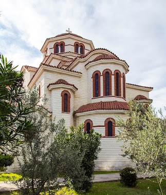
Church nearby Kisha e Shen Pavlit
Albania
Church nearby Kisha e Shen Pavlit
Kisha e Shen Pavlit
Rrushkull, Albania
contacts phone
:
+355
Latitude:
41.4299528
, Longitude:
19.5146923
larger map & directions
read more
nearest Church
7.074 km
Kisha Katolike Rinia
Rinia
Church
read more
8.249 km
Kisha katolike (Shën Gjergji)
Rruga Vath Turja
Church
read more
9.342 km
Kisha e Shen Vlashit
Shën Vlash
Church
read more
11.192 km
Qendra Kristiane e Durresit
Rruga Kristo Sotiri, Durrës
Church
read more
11.284 km
House of Prayer
Rruga Miqesia, Durrës
Church
read more
11.635 km
Saint Nicolas Church
Mallkuc Koder
Church
read more
11.795 km
Mbretëria Hall i Dëshmitarëve të Jehovait
Rruga Aleksander Goga, Durrës
Church
read more
12.274 km
Kisha e Mallkuçit
Mallkuç
Church
read more
12.635 km
Mbretëria Hall i Dëshmitarëve të Jehovait
Rruga Kodër Vorë, Vorë
Church
read more
12.687 km
Shen Dominiku
Durrës
Church
read more
12.741 km
Bazilika Gjuricaj
Durrës
Church
read more
12.994 km
Kisha e Krishtit Durres
Lagja 5, Rruga Kasem Durrësi, Durrës
Church
read more
13.035 km
Kisha e Bashkuar Metodiste
Durrës
Church
read more
13.165 km
Kisha Amerikane (Kurse Anglisht Falas)
Durrës
Church
read more
13.279 km
Kisha Reformuar Durres
Rruga Kadri Pirro, Durrës
Church
read more
13.495 km
Kisha Biblike e Durresit
41°19'12.6"N 19°26'44, P-9, Rruga Andon Naçi, Nr.175, Durres
Church
read more
13.5 km
Kisha Biblike Durres
Durrës
Church
read more
14.167 km
Xhamia Picar
Rruga e Serave
Church
read more
14.267 km
Shën Luçia
Rruga Don Nikoll Kacorri, Durrës
Church
read more
14.307 km
Bazilika Shen Mehillit, Arapaj
Arapaj
Church
read more
14.353 km
Kisha Ortodokse
Rruga Imzot Fan S. Noli, Durrës
Church
read more
14.353 km
Ortodox Church of Saint Pavel and Saint Ast Durres
Rruga Imzot Fan S. Noli, Durrës
Church
read more
16.022 km
Kisha e Shën Gjon Pagëzorit
Krujë
Church
read more
16.022 km
Kisha e Shën Gjon Pagëzorit
Krujë District
Church
read more
16.022 km
Kisha e Shën Gjon Pagëzorit
Distrito de Krujë
Church
read more
📑
all categories
Accounting
Administrative area level 1
Administrative area level 2
Airport
Amusement park
Aquarium
Art gallery
Atm
Bakery
Bank
Bar
Beauty salon
Bicycle store
Book store
Bus station
Cafe
Campground
Car dealer
Car rental
Car repair
Car wash
Casino
Cemetery
Church
City hall
Clothing store
Colloquial area
Convenience store
Country
Courthouse
Dentist
Department store
Doctor
Electrician
Electronics store
Embassy
Finance
Fire station
Florist
Food
Funeral home
Furniture store
Gas station
General contractor
Grocery or supermarket
Gym
Hair care
Hardware store
Health
Home goods store
Hospital
Insurance agency
Jewelry store
Laundry
Lawyer
Library
Liquor store
Local government office
Locality
Locksmith
Lodging
Meal delivery
Meal takeaway
Mosque
Movie rental
Movie theater
Moving company
Museum
Natural feature
Neighborhood
Night club
Painter
Park
Parking
Pet store
Pharmacy
Physiotherapist
Place of worship
Plumber
Point of interest
Police
Post office
Premise
Real estate agency
Restaurant
Route
Rv park, camping
School
Shoe store
Shopping mall
Spa
Stadium
Storage
Store
Supermarket
Taxi stand
Train station
Transit station
Travel agency
University
Veterinary care
Zoo
administrative area level 3
administrative area level 5
sublocality level 1
↑