School nearby Shkolla M.E Minarrolli
Albania
School nearby Shkolla M.E Minarrolli
Shkolla M.E Minarrolli
Pogradec, Albanien
contacts phone
:
+355
Latitude:
40.9007925
, Longitude:
20.6592964
larger map & directions
read more
nearest School
46 m
Shkolla Koli Gusho
SH3, Pogradec
School
read more
271 m
Shkolla Muharrem Çollaku
Pogradec
School
read more
486 m
Gjergj Pekmezi High School
Pogradec
School
read more
612 m
shkolla Gjok SHQIPTARI
Pogradec
School
read more
627 m
Gjok P. Shqiptari
Pogradec
School
read more
1.312 km
Shkolla AMARO TAN
Rruga Peliot, Pogradec
School
read more
1.655 km
Shkolla 9-vjeçare Servet Agolli
Buçimas
School
read more
2.145 km
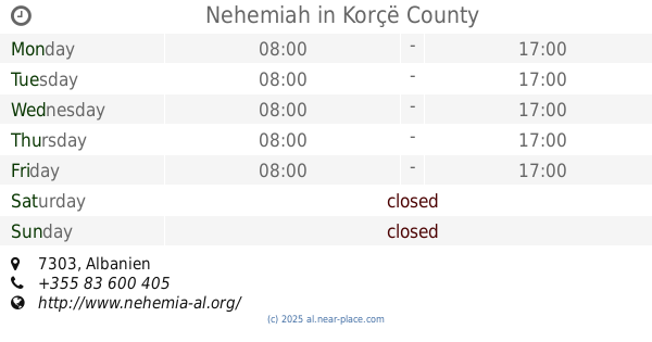
Nehemiah
School
read more
7.919 km
Qemal Bazelli Cerrave
Çërravë
School
read more
31.991 km
Shkolla e Re
Rruga Pandeli Vangjeli 1, Korçë
School
read more
32.27 km
Gjimnazi Raqi Qirinxhi
Korçë
School
read more
32.609 km
Shkolla Bujqesore "Irakli Terova"
Korçë
School
read more
33.099 km
Gjimnazi Themistokli Germenji
Korçë
School
read more
33.22 km
Liceu Korçë
Korçë
School
read more
33.322 km
Shkolla Sevasti Qiriazi
Rruga Foqon Postoli, Korçë
School
read more
33.681 km
Congregation of Jehovahs Witnesses
Rruga Pandi Cifligu 8, Korçë
School
read more
33.816 km
Medreseja e Korçës
Rruga Thanas Mertiri, Korçë
School
read more
34.051 km
Shkolla 9 vjecare "Nuci Naci"
Korçë
School
read more
35.796 km
Shkolla Rakip Kocibelli
Qatrom
School
read more
36.937 km
Shkolla "Fuat Babani"
Baban
School
read more
39.848 km
Shkolla Asllan Shahini
Rruga Kodrionasit, Gramsh
School
read more
53.627 km
Shkolla Naim Frashëri
Elbasan
School
read more
53.641 km
Shkolla Jopublike Arianiti
Rruga Beharedin Mitarja, Elbasan
School
read more
53.809 km
KRYQI KUQ ELBASAN
Rruga Gezim Jazaxhiu, Elbasan
School
read more
57.204 km
Refat Keli
Rruga Gjimnazi, Poliçan
School
read more
📑
all categories
Accounting
Administrative area level 1
Administrative area level 2
Airport
Amusement park
Aquarium
Art gallery
Atm
Bakery
Bank
Bar
Beauty salon
Bicycle store
Book store
Bus station
Cafe
Campground
Car dealer
Car rental
Car repair
Car wash
Casino
Cemetery
Church
City hall
Clothing store
Colloquial area
Convenience store
Country
Courthouse
Dentist
Department store
Doctor
Electrician
Electronics store
Embassy
Finance
Fire station
Florist
Food
Funeral home
Furniture store
Gas station
General contractor
Grocery or supermarket
Gym
Hair care
Hardware store
Health
Home goods store
Hospital
Insurance agency
Jewelry store
Laundry
Lawyer
Library
Liquor store
Local government office
Locality
Locksmith
Lodging
Meal delivery
Meal takeaway
Mosque
Movie rental
Movie theater
Moving company
Museum
Natural feature
Neighborhood
Night club
Painter
Park
Parking
Pet store
Pharmacy
Physiotherapist
Place of worship
Plumber
Point of interest
Police
Post office
Premise
Real estate agency
Restaurant
Route
Rv park, camping
School
Shoe store
Shopping mall
Spa
Stadium
Storage
Store
Supermarket
Taxi stand
Train station
Transit station
Travel agency
University
Veterinary care
Zoo
administrative area level 3
administrative area level 5
sublocality level 1
↑