Bakery nearby Pastiçeri DRINI
Albania
Bakery nearby Pastiçeri DRINI
Pastiçeri DRINI
Peshkopia, Albanien
contacts phone
:
+355 67 211 5010
Latitude:
41.683098
, Longitude:
20.4280016
larger map & directions
read more
nearest Bakery
221 m
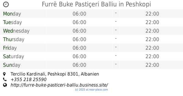
Furrë Buke Pastiçeri Balliu
Tercilio Kardinali, Peshkopi
Bakery
read more
44.236 km
Pasticeri ANDORA
Rruga Pavaresia, Kukës
Bakery
read more
60.364 km
Furre Buke Pasticeri Melisa
Tirana
Bakery
read more
60.506 km
Furre Buke Pasticeri Maxhaku 2
Unnamed Road
Bakery
read more
61.882 km
Pasticeri SPAHIU
Metrush Luli, Tiranë
Bakery
read more
61.946 km
Furre Buke Losha 2
Tirana
Bakery
read more
61.982 km
Furre Buke Reka
Unaza e Madhe, Tiranë
Bakery
read more
62.512 km
Furrë Buke A Chef
Tirana
Bakery
read more
62.588 km
Furrë Buke 'Tani'
Tirana
Bakery
read more
62.647 km
Furre Buke Pasticeri Tito
Xhanfize Keko, Tirana
Bakery
read more
62.674 km
Furrë Buke • Pastiçeri • Sulaj
Rruga Hamdi Sulcebe, Tirana
Bakery
read more
62.875 km
Pasticeri BILBILI
Tirana
Bakery
read more
62.997 km
Chicago Bakery
Rruga Idriz Dollaku, Tirana
Bakery
read more
63.071 km
Pasticeri Sulaj
Rruga Ali Demi 148, Tirana
Bakery
read more
63.154 km
Furrë Buke "Qato"
Tirana
Bakery
read more
63.34 km
Pastiçeri Nefeli
Rruga Asdreni
Bakery
read more
63.37 km
Furrë Buke Dejan
Rruga Petro Nini Luarasi, Tiranë
Bakery
read more
63.394 km
Furrë Buke Pastiçeri Mesdheu
Rruga Hoxhë Vokrri, Tirana
Bakery
read more
63.422 km
Furra
Rruga Todi Shkurti, Tirana
Bakery
read more
63.483 km
Furri Elektrikut
Rruga Qemal Stafa, Tiranë
Bakery
read more
63.652 km
Buka Thethi
Rruga Tefta Tashko-Koço, Tirana
Bakery
read more
63.75 km
Buke Pastiçeri Durrësi
Tirana
Bakery
read more
63.77 km
Lej & Laj
Rruga Petro Nini Luarasi, Tiranë
Bakery
read more
64.045 km
Almera Furrë Buke
Rruga Mustafa Lleshi, Tirana
Bakery
read more
64.069 km
Buke Pasticeri Durresi
Rruga Pjeter Budi, Tiranë
Bakery
read more
📑
all categories
Accounting
Administrative area level 1
Administrative area level 2
Airport
Amusement park
Aquarium
Art gallery
Atm
Bakery
Bank
Bar
Beauty salon
Bicycle store
Book store
Bus station
Cafe
Campground
Car dealer
Car rental
Car repair
Car wash
Casino
Cemetery
Church
City hall
Clothing store
Colloquial area
Convenience store
Country
Courthouse
Dentist
Department store
Doctor
Electrician
Electronics store
Embassy
Finance
Fire station
Florist
Food
Funeral home
Furniture store
Gas station
General contractor
Grocery or supermarket
Gym
Hair care
Hardware store
Health
Home goods store
Hospital
Insurance agency
Jewelry store
Laundry
Lawyer
Library
Liquor store
Local government office
Locality
Locksmith
Lodging
Meal delivery
Meal takeaway
Mosque
Movie rental
Movie theater
Moving company
Museum
Natural feature
Neighborhood
Night club
Painter
Park
Parking
Pet store
Pharmacy
Physiotherapist
Place of worship
Plumber
Point of interest
Police
Post office
Premise
Real estate agency
Restaurant
Route
Rv park, camping
School
Shoe store
Shopping mall
Spa
Stadium
Storage
Store
Supermarket
Taxi stand
Train station
Transit station
Travel agency
University
Veterinary care
Zoo
administrative area level 3
administrative area level 5
sublocality level 1
↑